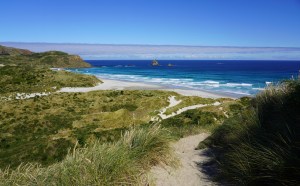
Sandfly Bay, Otago Peninsular, South Island, New Zealand
All of the photos are here or you can see each regions photos using the links in the relevant sections below.
1. Dunedin and the Otago Peninsula:
Dunedin and the Otago Peninsula area photos are here.
Leaving Fiordland behind us we drove east towards the coast 3½ hours from Te Anau to Dunedin feeling a bit glum. After over a month in the mountains we didn’t want to leave the snowy peaks, the glaciers or the lakes behind us.
It made matters worse that we didn’t like Dunedin at all (our home for the next 5 nights). It wasn’t a cute historic town (as promised by the advertising) but a busy, noisy, slightly down at heel, grungy city. Birdsong was replaced by police sirens and mountain views were replaced with a concrete jungle – a port, Speight’s brewery’s tall brick chimney topped with a painted beer barrel and a sea of corrugated iron. Yikes!
It was an expensive mistake to make 😉 We stayed one night which gave us two full days (to do the highlights) and we then checked out of our Airbnb in the city early …
Outside of the city itself, the surrounding area has a lot to offer – specifically:
a. The Otago Peninsula – which is absolutely stunning! In 20 minutes from the city you can be in Sandfly Bay.The drive on winding Highcliff Road across the Peninsula is beautiful in its own right with views over fields, farmland, the ocean and the harbour. From the car park at Sandfly Bay we sand-surfed in hiking boots down the steep sandy cliffs and over rolling sand dunes to the beach. It is known for its bright blue water, white sand and wildlife. There were sea lions sleeping on the sand recovering from their exertions – from time to time flicking sand over their backs to stay cool. As New Zealand beaches go, this one is a stunner for a late afternoon walk.
b. St Clair/St Kilda beach is a huge swathe of golden sand and teal water. If you drive or walk east along John Wilson Ocean Drive towards Lawyers Head and the Sir Leonard Wright Lookout, the views over the beach and headlands are fabulous. Watch out for sea lions who might have inadvertently flippered their way too far from the water and up onto the roadside!
c. The street art in Dunedin partly made up for the town itself. We downloaded an interactive street map to locate the paintings at https://www.dunedinnz.com/insiders/the-insiders-guide-to-the-dunedin-street-art-trail many of which are in the renovated Warehouse Precinct and dotted around the back streets of the Octagon. Artistic highlights were various images of mythical creatures by British street artist Phlegm, Pixel Pancho’s fabulous steampunk jockey, a shiny silver bull on a black wall (by Bik Ismo), various stylized weird and interesting creatures by Cracked Ink, and a deep sea diver by Milarky.
2. Oamaru:
Oamaru area photos are here.
The following afternoon we drove north to Oamaru to our new Airbnb out in the countryside in Georgetown. The house was located miles from anywhere at the end of a dusty track on farmland. We had expansive views over the valley, a stream and a forested escarpment where we watched cows grazing instead of trash blowing through the streets. Oamaru was a breath of fresh air, much smaller and far more peaceful than Dunedin for a couple of nights.
Unmissable bonuses in Oamaru:
a. Steampunk HQ (a museum of sorts) described in its own advertising as a “quirky and fun genre of science fiction” featuring steam-powered technology and set in an “alternate, futuristic version of 19th century Victorian England” … which is exactly what it was! It was part sculpture and part Jules Verne and for $15 NZD per person you can fiddle with knobs and twisty things and push buttons – lights will flash and sirens will wail. The Yard is a big boys interactive playground with steam train carriages, giant motorcycles and repurposed tractors. Amongst other sci-fi “inventions” there is a Dismembulator Cannon which hurls plasma balls towards invading sky pirates and moon-men … there is a ship unearthed in the Cerberus quadrant of Ursa Major used for transporting the dead to their new home in the Underworld. The Portal described as “a gateway to other dimensions, both real and imagined” is through a doorway to a platform where you are surrounded by glass panels and bright lights which change color in rhythm with the background music. All good fun! However, I’m relieved I talked Geoff out of buying the spooky Steampunk Goggles as a souvenir 😉
b. The historic Oamaru Victorian Precinct – renovated warehouses and impressive historic buildings built in the town’s famous “whitestone” (limestone). There are Victorian buildings, some Georgian and some clearly in the Venetian Renaissance style. We loved the area around Tyne Street and Harbour Street (check out Harbour Street Bakery for their famous cinnamon rolls). On Thames Street in the commercial sector of town the banks, the court house and the opera house have more classical lines. By coincidence, Netflix had just finished filming a movie based on John Steinbeck’s book “East of Eden”. The movie crew were clearing the streets of mud and dirt and original facades were being replaced, so the streets of the historic precinct were unusually quiet and devoid of tourists. Don’t miss the beautiful Victorian Station repurposed as a Japanese restaurant with tables laid out on the platform!
c. Whitestone Cheese Diner and Deli – great homemade cheeses and cheesecake.
d. Sawaddee Thai Massage – more pressure points than massage but excellent!
Still, you can’t spend too long in Oamaru without climbing the walls because it’s not the most exciting region but if you need to literally blow the cobwebs out of your ears then head to breezy S14 beach on Beach Road just south of the town. You might see a couple of sea lions wallowing on the sand or the rocky headland at the north end of the beach. Not one of the country’s finest beaches but good to stretch your legs.
There is also a famous Blue Penguin Colony where (if you can get tickets) you can join 250 other people seated in an arena at 9pm trying to spot tiny blue penguins make their way up the beach in dusk. We didn’t bother since the check-in lady told me they hadn’t seen many penguins in a few days.
3. Christchurch and the Akaroa Peninsula:
Christchurch and the Akaroa Peninsula area photos are here.
a. Christchurch is a much nicer city than Dunedin. Cleaner and more spacious with a good mix of new and older heritage buildings. Areas to visit include the Transitional Cardboard Cathedral (more on that below), Riverside Market (very touristy but home to the Avon River and ROCA Mediterranean Restaurant which was very good for lunch), Cashel Street Mall, the spectacular landmark Art Gallery constructed in waves of blue glass, the urban SALT district with repurposed warehouses and modern cafes and restaurants (you can also find some of the best street art here). Tour trams trundle up and down Cashel Street and criss-cross the city and during weekends you can hire a punt to glide under the bridges on the Avon River. The scale and variety of the street art was very impressive … we used this interactive map https://watchthisspace.org.nz/#map
A bit of history on Christchurch – the February 2011 earthquake killed 185 people and caused immense damage to the city, in particular to its iconic Cathedral. A temporary cathedral was constructed on the site of a church which was demolished after the earthquake and is constructed from 98 23″/60cm diameter cardboard tubes and 20 foot/6 metre shipping containers. The earthquake was very shallow, only 3 miles below the earth’s surface, which is one of the reasons it was so devastating. The effects were felt all over the South Island and as far as the Tasman Glacier 120 miles away where 30 million tonnes of ice tumbled from the glacier into the Tasman Lake hitting tour boats with tsunami waves 11 feet high. Pretty scary stuff …
b. We were based outside the city in a house on a hill overlooking the posh suburb of Redcliffs and out across the tidal estuary to Pegasus Bay. The main purpose for staying in the area was to explore Akaroa and the Banks Peninsula (massive compared to Dunedin’s Otago Peninsula and just as spectacular). The drive from the suburbs takes you past the port city of Lyttelton and as the road weaves along the coast around Cass Bay, Corsair Bay, Rapaki Bay and Governors Bay the scenery becomes more and more beautiful especially in the early morning light which cast shadows over the headlands and surrounding mountains. The landscape is a combination of tiny settlements, marshland flats, bucolic rolling hills and farmland. You can see Akaroa and the sun glinting on its harbour waters from the winding mountain road a few miles before you reach it. Akaroa, almost at the end of the Banks Peninsula, is a very small town an hour and 40 minutes (but a world away) from Christchurch city. It is the Province of Canterbury’s oldest town and was founded by French settlers in 1840 before the Brits declared sovereignty over New Zealand effectively cutting off the colonist’s foothold. Popular again with the French from the 1960’s onwards there is a definite nod to its French heritage with streets renamed “rue” and a popular French Bakery. We ate at Ma Maison on the waterfront which was excellent. The waterfront and harbour are very pretty and there are excursions to swim with Hector’s dolphins (some of the world’s smallest dolphins) but our trip was canceled due to high winds. If you’re in town for long enough you could hike the 3 day Banks Peninsula Track.
Other highlights of the Akaroa town area are:
– Shamarra Alpaca Farm Tours where you can hand feed greedy alpacas and cuddle the most chilled out, friendly ones. The boys are chilled and the girls are voracious. They ran at us like greyhounds out of their racing traps at full speed once we’d been spotted with a bucket of grass cuttings! We had a great time petting and hand-feeding them. I adore alpacas and it’s only a matter of time before I convince Geoff to move to Colorado and open my own alpaca farm 😉 It was exhausting fending them off … if you don’t keep your wits about you you’ll be surrounded by 3 or 4 making a pincer movement towards your bowl. It was an excellent one hour tour!
– Fishermans Bay Garden at the end of a dirt track overlooking rugged headlands and the ocean. The gardens are the long-time dream of the owners of the house and farm – a decades old labour of love. You can wander alone through the hillside terraces and winding pathways filled with native and non-native plants, flowers and sculptures. It was incredibly peaceful.
– The Ōnawe Peninsula – a tiny peninsula jutting into Akaroa Harbour and once the site of a Maōri village. You reach it via Ōnawe Flat Road, a single lane dirt track with the harbour on one side and some attractive old fishing huts. The track takes one of two routes – you can climb the dusty, short, steep hill immediately ahead of you or, if the tide is out, you can walk alongside the rocky outcrops to the main headland. We hiked to the top of the first rocky outcrop for a view over the peninsula. It was only 10 minutes up and down but every one of them was nerve-wracking – the summit is a skinny, narrow track with steep drop-offs on both sides. There was no way I was scrambling any further and taking an unexpected dip in the sea 😉
c. Other things to do in the Christchurch area – coastal and headland trails. We walked the 3.7 mile Cass Bay to Corsair Bay track through wooded areas passing beaches packed with teenagers sunbathing and swimming in the murky tidal waters of the bay. It was fine to stretch your legs but not terribly exciting! We also walked the 5 mile return Governors Bay Heritage track from the Allendale Reserve which meanders alongside muddy tidal inlets, past the brand new Governors Bay jetty and uphill on a narrow track before a steep (but mercifully brief) descent on a very dodgy set of steps with nothing but a rope handrail between you and plunging to a rocky death. At the bottom you can clamber over rocks into a cave known as the Māori Gardens. More of a leg stretch than the Cass Bay trail but overall we struggled to find the area as breathtaking as we’d got used to in the mountains and lakes in Otago, the West Coast and Fiordland! We had been very spoiled in our first 6 weeks on the South Island!
d. We can’t visit any new region without having a Thai Massage – Diamond Thai Massage in Redcliffs was the full works – deep tissue, Thai stretching and the excruciating experience of having your inner thigh muscles walked upon! So good we visited twice in 5 days.
e. After a Thai massage what could be better than a vegetable Panang Curry for dinner? La Ruby Thai Restaurant in Ferrymead was very good.
f. Vic’s Bakehouse Artisan Bread Makers in Ferrymead for all bread supplies and, in particular, excellent organic white sourdough. The hype for this hole-in-the-wall bakery was entirely justified! Bakeries are decidedly average in New Zealand … this one stood out …
4. Abel Tasman National Park, Mapua and Wharariki Beach:
Abel Tasman National Park, Mapua and Nelson area photos are here.
This is one of the prettiest regions and perhaps one of the most livable – rolling hills, vineyards, country cottage gardens with roses, hydrangeas and agapanthus, and access to the golden sand beaches of Tasman Bay. Nelson and the Abel Tasman region is considered the sunniest region in New Zealand. Our week in Mahana (a few miles from Mapua on the Ruby Bay coast) was unexpectedly beset by dreary and wet weather. In between downpours we managed to squeeze in some of the regional highlights:
a. Wharariki Beach at the far end of Golden Bay (just north of Abel Tasman National Park). It took just under 2½ hours to drive to the South Island’s most northerly beach from our apartment in Mahana. Exposed and subject to constant winds funneled between the headlands it’s no wonder that the beach has huge and spectacular sand dunes. We parked at the Archway Cafe (good for a pre-hike snack) and walked the 20 minute trail which crosses farmland and over grassy slopes before reaching the first of the sand dunes and an epic view of the sea stacks in the distance. Huge swathes of white sand blown in wave formations spreads below you. It’s a beautiful, wild but challenging place. It was a tough choice between having your epidermis sand-papered in the ceaseless blasts of sand at the beach or being blown off a clifftop in 40mph gusts. Even at the beach it was a fairly constant 25mph wind. The tide was somewhat in our favor so we walked towards the caves between the huge headlands and the rock formations out to sea at the southern end the beach. It would be a great beach to walk because it stretches for miles and even though the car park may look busy, the expanse of the sand is so immense you barely notice other people. It’s not a swimming beach – the waves were pounding on the shore and crashing in huge waves between the sea stacks. We had planned to walk the headland trail to Cape Farewell – a moderately challenging 3 mile return walk. It should have been a piece of cake but it wasn’t. We missed the start of the hike because we’d gone off-piste in the caves and had to follow the beach inland along a tidal river deep brown with tannin. Boots and socks off and we waded through the shallow river before scrabbling through the undergrowth on the opposite bank to find the official start of the track. The track is very steep and overgrown in most places. Passing around the inner forested sections of the headlands, we ducked under tree limbs and scraped through undergrowth past thorny bushes on a track barely wider than a single foot with a steep drop-off into the forest below to one side. Not easy – but at least on the inner tracks we were out of the 40mph gusts which greeted us at the top of the rugged, grassy headlands. It was hard going and, if I’m honest, the most exceptional views are from just above the tannin brown river when you start to gain some height over the beach. At the far end of the track at Cape Farewell there is also a beautiful view over the headlands. Geoff was blown clean off his feet landing on his butt in the grass on the headland (I’m sure I only remained upright because I was pinned into the ground by my hiking poles 😉) and once more on down at the beach when he was blown face forward into the sand on a sand dune … this place is lethal 😂
Luckily we escaped without serious injury … it was well worth the drive up there because it is a spectacular beach. The route itself driving north from the Mapua region passes over the winding, mountainous Takaka Hill with views over the entire valley (if you’re lucky you might see a rainbow stretching from one side of the valley floor to the other in a full technicolor sweeping arc!). We didn’t have time to stop but the arty, slightly hippie town of Takaka looked pretty – instead we took a side road just north of the town for a flying visit to Te Waikoropupū Springs (also known as Pupu Springs which is much easier to remember!). You only need 15 minutes to walk the loop through mānuka and kānuka forest to the spring, take a few snaps and marvel at the crystal-clear iridescent blue water. Its clarity is measured at 207 feet/63 metres (all but optically pure water) and the spring discharges 3,700 gallons/14,000 litres of water per second. The spring is a sacred treasure to the maoris and is well worth a visit!
b. Abel Tasman National Park! Wilsons Abel Tasman is a tour operator based in Kaiteriteri the gateway to the National Park (which itself also has a spectacular golden/orange beach). Wilsons offers a multitude of watery options to get into the park itself. 15 years ago we kayaked around Split Apple Rock to Marahau Beach and hiked back to town. The water was crystal clear, emerald green and calmer than a millpond. During our week this time it was churned up with all of the windy, stormy weather the region has endured this summer so kayaking didn’t appeal. Instead we booked the 9.15am 1 hour water shuttle from Kaiteriteri to Medlands Beach about a third of the way up into the park. Leaving the tour groups in the dust we sprinted off on an 8 mile hike crossing swing bridges and streams in a mainly forested hike with occasional glimpses of the blue waters of the national park in the distance. It isn’t a hard hike but it is quite long when you add detours to Sandfly Bay and Cleopatra’s Pool into the mix. The first beach landing you make is Torrent Bay with its long spit of sand protruding like a tongue into the bay. If the tide is in your favor (it wasn’t for us) you can wait for the shallow water in the bay to recede and cross at the orange markers to take a shortcut to Anchorage Bay. We were to meet our pre-booked shuttle in Anchorage Bay at 3.30pm. If you can’t take the shortcut then you still have another 90 minute hike to take the inland forested route and the detour to Cleopatra’s Pool. Cleopatra’s Pool was crowded and quite the gigantic fuss about nothing … the rocky stream to the right of it was much prettier. Anchorage Beach was our final destination where we had enough time to chill out, have a picnic, take a paddle and catch a few rays. Abel Tasman’s beaches are renowned for their lush forests and golden orange sand. Anchorage has rocky cliffs and wave-carved caves at the northern end which you can sit under for shade before the shuttle eventually picks you up halfway down the beach. Wilsons shuttle is very well organized and efficient unless the captain drops the gangplank too far back from the sand when you’re disembarking. Poor Geoff was hit at the critical moment stepping off the boat with a huge wave filling his boots and hiking pants with saltwater and sand … oh dear 😉
c. Cable Bay and Pepin Island are just north of the city of Nelson – a 20 minute drive winding through farmland and hills. The island is privately owned and connected by a narrow causeway to the tiny settlement of Cable Bay. The island is wedged between the Tasman Bay on one side and Delaware Bay. We walked the Cable Bay Walkway to Sentinel Lookout from the beach – only 1.2 miles return but somewhat of a ballbuster as it’s steep, doesn’t have any shade and we thought it would be a great idea to do it on one of the hottest days during our week in the region! The views over the headlands, the rocky beach and causeway, the deep blue waters of the Tasman Bay and the contrasting milky teal waters of the inlet were well worth the sweaty exhaustion. There were cows grazing on purple thistles and butterflies and it would have been very peaceful if it hadn’t been for the two of us wheezing like pit donkeys up the steep climb on the track which, to make matters worse, was radiating heat beneath us and slow cooking our feet. Back at sea level, we stopped for lunch at Cable Bay Cafe which was understandably very popular with locals. We sat on the terrace in the garden sipping homemade lemonade and coffee which was far more civilized than sweating up the hill for an epic view and a few photos 😉 The toasted bagels and homemade cakes were all excellent and alone the food would have been worth the drive out there.
d. Mapua Wharf is a well-known tourist spot with restaurants overlooking the water (or mud flats if the tide is out). A great place for a beer, fish and chips overlooking the water (or mud 😉) , dinner at renowned The Apple Shed and an ice-cream from Hamish’s!
e. You can either take a ferry from Mapua Wharf or drive around the peninsula to Rabbit Island and walk for miles along the sand admiring the distant reflections of Nelson and its headlands in the wet sand at the waters edge.
f. Naturally we visited a Thai Massage Spa – Dissaya Thai Massage in Motueka! However, we can’t recommend it … neither can we recommend a highly rated bakery in Motueka – Patisserie Royale – which was well below average … We stopped by the cute garden cafe Garden House Kina for some farm grown fruit and veg and homemade cakes – it’s very pretty – like an English country garden which came as no surprise once we discovered that the owner was from England. Komitimiti Riverside Cafe in Lower Moutere is a very quirky, rustic, not-for-profit cafe connected to the next door commune – worth a stop for breakfast or lunch overlooking the cacti garden.
g. Nelson is a small attractive arty city. Avenues of trees with hanging flower baskets line the streets of independent businesses and cafes. The Suter Art Gallery and craft store with adjoining Suter Cafe overlooking the pond in the immaculately maintained Queen’s Gardens was very pleasant. It’s a pretty quiet town considering it’s the biggest in the region.
5. Blenheim, Picton and Queen Charlotte Sound:
Blenheim, Picton and Queen Charlotte Sound area photos are here.
We were staying in a modern Airbnb in Fairhall, a few minutes drive from Blenheim which is a very famous wine-growing region in Marlborough. Perched on a hilltop overlooking miles of rolling vineyards, we sipped tea in bed watching the sun rise over the dusty golden foothills and iridescent green vineyards. Whichever direction you look in this valley there are vineyards – many of them extremely famous. They are interspersed with fields of sunflowers designed to attract bees for pollination and to distract birds away from the grapes. It is all very pleasant, peaceful and serene – especially in the early evening wandering down from our house through the vineyards for a stroll. There were butterflies fluttering around us and bees buzzing, heavy with pollen from the sunflowers. During the few days we spent here (before leaving the South Island and flying north to Wellington on the North Island) the highlights were:
a. Picton Harbour lying at the head of Queen Charlotte Sound – an important transport hub ferrying people, mail and supplies to the businesses and homes dotted sporadically throughout the many fjords of the Marlborough Sounds. The sounds are deep blue backed by dark green forested headlands. The most famous hike is the 45 mile Queen Charlotte Track. For a quick taste of the scenery we walked the short Snout Track and Lower Bob’s Bay Track loop from picturesque Picton Marina. It was only a couple of miles which wound uphill on a steep incline through the forest and around the headland before returning along a dirt track via Bob’s Bay beach and the waterfront to the marina.
b. The main purpose of visiting the region was to hike part of the iconic Queen Charlotte Track. We took the 8am Cougar Line shuttle ferry to Resolution Bay to hike the 7¼ mile track over the Tawa Saddle headland via the (Tawa Bay Scenic Reserve) before weaving down to the head of Endeavour Inlet where we met the return ferry at Furneaux Lodge at 3:15pm. We pre-booked the out and back ferry since it was high season. The ferry makes various scheduled and unscheduled stops at lodges, and homes on the waterfront – the outward trip took 1½ hours to reach Resolution Bay but it was a slow 2 hour ride back from Furneaux Lodge to Picton Marina via secluded inlets and tiny bays. The views from high up on the track are even more breathtaking than from down at the water. Forested headlands spread like skinny emerald fingers into the deep blue waters of Queen Charlotte Sound. After disembarking at Resolution Bay there was a short, steep incline from the jetty through the Resolution Bay Cabins property to the start of the track. It was an easy hike and very peaceful with nothing but the sound of birdsong and the occasional deafening rhythmic buzzing of cicadas to accompany us. We had booked a post-hike lunch at Furneaux Lodge as we had plenty of time to kill after the hike before the Cougar Line ferry was scheduled to collect us at the Lodge jetty. The food was surprisingly good for a lodge in the middle of nowhere … it’s not often you finish a hike in the relative wilderness, have a quick paddle in a fjord and sit on a verandah in the sunshine sipping wine in your hiking boots … all very civilized! 😉
c. Dinner at Harvest Restaurant – part of The Marlborough Estate and Vineyard in Rapaura – a farm-to-table restaurant with excellent wines overlooking a manicured lawn and a rose garden. Sunset over the vineyards was absolutely beautiful.
d. Marlborough Sunday Market at A and P Showgrounds is a popular weekly event where local families come out to sit in the sun on the grass banks with ice-creams listening to live music. There are some quirky but interesting vendors selling cheeses, pies, fresh flowers and local fruit and veg. Definitely worth an hour if you’re in the area.
It has been a whirlwind 2 months in the South Island (see my earlier blog post for the South Island – Lakes and Mountains regions). We’ve hiked icy blue glaciers, taken 3 helicopter flights over mountains and valleys with snow landings on glaciers and remote lakes, climbed up a 1,000 foot/305 metre waterfall, glided on an underground river in the pitch black as blue glowworms quivered overhead … we’ve soaked in spring-fed hot tubs in the rainforest, jet-boated on shallow icy blue rivers and through narrow canyons and we’ve cruised on deep blue fjords … we’ve hiked endless miles up mountains, through passes and along coastal tracks and wandered through waist high wild lupins … we’ve cuddled alpacas, been blown face first into sand dunes and knocked clean off our feet on a clifftop in 40mph gusts. It’s been truly amazing. The South Island is a wild and wonderful natural treasure … it’s hard to leave but it’s time to head north and catch our ½ hour flight from Blenheim Airport to Wellington, New Zealand’s capital, on the North Island.
Categories: Akaroa, Alpaca Farm, Australasia, Banks Peninsula, Blenheim, Cable Bay, Christchurch, Dunedin, Fairhall, Fairhall, Hiking, Kaiteriteri, Mapua, Nelson, New Zealand, Otago Peninsula, South Island, Street Art, Travel, Wine Tasting

Morning Jennie
Thank you for all your wonderful pictures and narrative. I almost feel I am there. Oh sorry I forgot to say Happy New Year to your last post.
Keep well both of you and continue sending the wonderful pictures.
Take care both.
Pauline xx
Sent from my iPhone
LikeLike
Hi Pauline! Apologies i didn’t see your note until now. Glad you are enjoying the blog! We’re back home in the perpetual sunshine enjoying home for a while. Hope all is well with you and your family x
LikeLike
Hi. No apologies needed. You were on holiday and enjoying seeing wonderful things. Just glad you are now home safe and well.
We are all well thank you. Enjoying my seeing grandchildren and enjoying my retirement. Lovely being with Brian everyday.
Still enjoy your rest which you probably need after those last month or so.
Take care and stay safe.
Lots of love
P xx
Sent from my iPhone
LikeLike